BY KD SUAREZ

MANILA, Philippines (4th UPDATE) – The Visayas and parts of Luzon and Mindanao is bracing for the arrival of typhoon Yolanda (international codename Haiyan), a severe weather system which meteorologists here and abroad have tagged as one of the planet's most catastropic super typhoons this year.
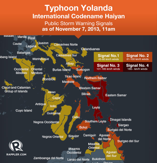
Storm warning signals have been raised in the entire Visayas, Bicol, Caraga, and parts of northern Mindanao and south Luzon, as the system maintains it strength while approaching Eastern Visayas, state weather bureau PAGASA said.
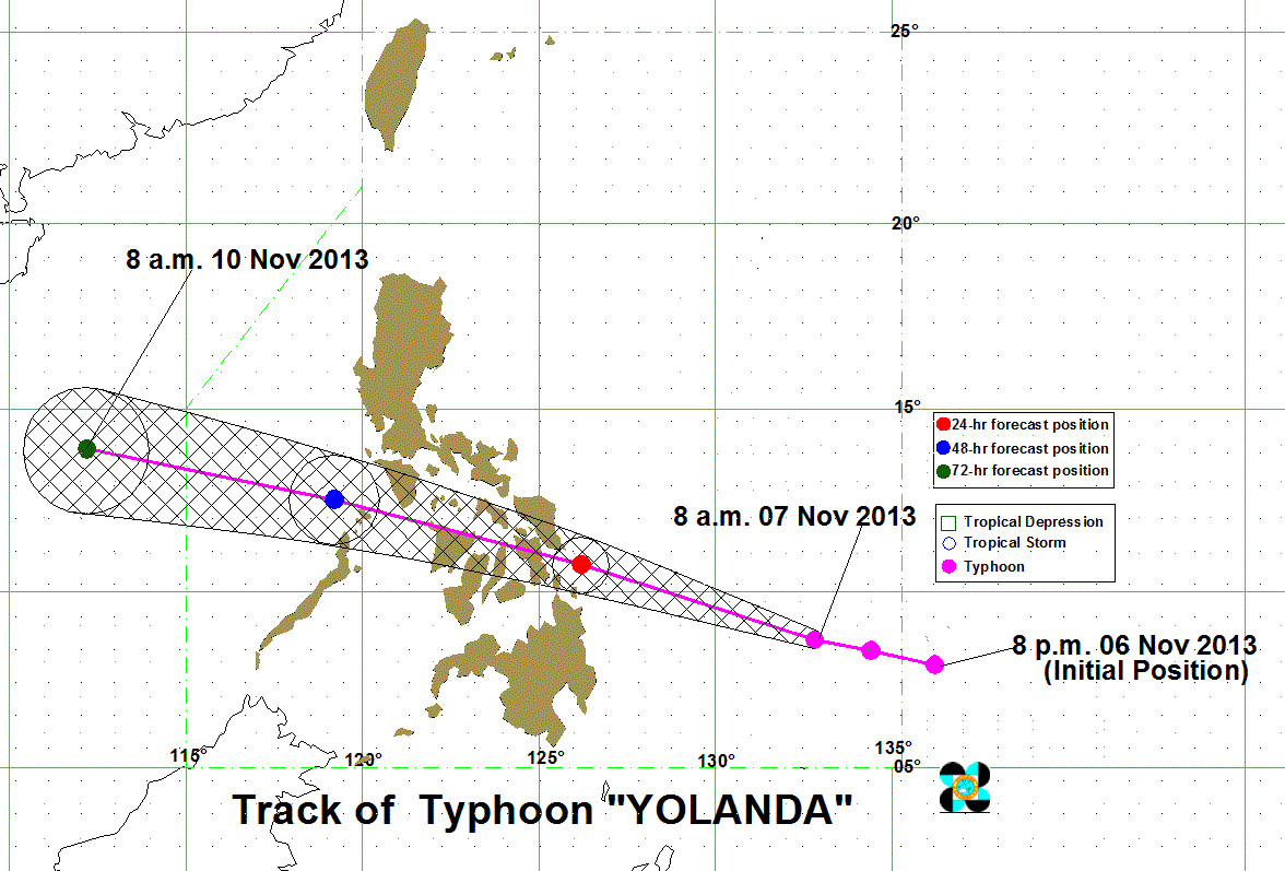
As of 10 am Thursday, the system was located 637 kilometers east of Hinatuan, Surigao del Sur, or 738 km southeast of Guiuan, Eastern Samar, carrying maximum sustained winds of 215 kilometers per hour near the center and gusts of up to 250 km/h.
Storm warning signal number 3 has been raised in the following areas:
- Siargao Island and Dinagat Province
- Eastern Samar
- Samar
- Leyte
- Southern Leyte
These areas can expect winds of 101-185 km/h within 18 hours. There will be heavy damage to agriculture; moderate to heavy disruption to power and communications; damage to structures made out of light to medium materials; and large trees could be uprooted.
Travel by any means – land, sea, or air – is dangerous.
Storm signal number 2, where winds between 61-100 km/h is expected within the next 24 hours, has been raised over these areas:
- Surigao Del Norte
- Camiguin
- Surigao Del Sur
- Agusan Del Norte
- Northern Samar
- Biliran
- Bantayan and Camotes Islands
- Northern Cebu including Cebu City
- Bohol
- Sorsogon
- Masbate and Ticao Island
There will be moderate damage to agriculture, particularly to rice and corn; partial damage to structures made of light materials; and sea and air travel will be risky.
Storm signal number 1, meanwhile, has been raised over a wider area:
- Misamis Oriental
- Agusan del Sur
- Aklan
- Capiz
- Iloilo
- Antique
- Guimaras
- Negros Occidental
- Negros Oriental
- Rest of Cebu
- Siquijor
- Camarines Norte
- Camarines Sur
- Catanduanes
- Albay
- Oriental Mindoro
- Occidental Mindoro
- Burias Island
- Romblon
- Marinduque
- Calamian Group of Island
- Southern Quezon
These areas should expect winds of 30-60 km/h within the next 36 hours, the bureau warned. There will be some damage to agriculture, and travel via sea in small vessels could be risky.
Heavy to intense rainfall (10.0-30.0 mm/h) is expected within the typhoon's 600 km diameter, the bureau said. NASA Tropical Rainfall Measuring Mission (TRRM) said rainfall around the eye is heavy, at around 100 mm/~3.9 inches per hour.
A total of 806 municipalities and cities will receive at least 40 mm of 3-hour accumulated rainfall brought by the typhoon, according to data released by the National Operational Assessment of Hazards.
Residents in areas under all storm signals should be on the lookout for possible flash floods and landslides, while storm surges up to 7 meters is possible in places under signals number 2 and 3.
Landfall in Guiuan, Eastern Samar Friday

It is forecast to move west northwest at a speed of 30 km/h, and is expected to still take a path that will bring it to the Visayas.
Yolanda earlier passed by the Republic of Palau. The island nation experienced tropical storm conditions, with winds between 63-100 km/h, Weather Philippines said.
As of noon Thursday, satellite images showed the typhoon's outer rainbands are already hovering over Eastern Visayas and eastern Mindanao, and as the typhoon moves closer, weather conditions are seen to deteriorate in the area.
The eye of the typhoon is expected to make landfall Friday morning, November 8, in the vicinity of Guiuan, Eastern Samar between 9-10 am.
It will then pass through the Visayas. After hitting Guiuan, it will traverse Leyte, Biliran, the northern tip of Cebu, Iloilo, Capiz, Aklan, Romblon, Semirara island, the southern portion of Mindoro island, and Busuanga.
It is expected to bring very strong winds and heavy rain over the Visayas, northern Mindanao, and southern Luzon, including the areas devastated by the magnitude 7.2 earthquake last October 15.
It will leave Philippine landmass Saturday, and will exit the PAR by Sunday, November 10.
PAGASA will again issue a bulletin at 5 pm Thursday.
'Extremely catastrophic'

Local and foreign meteorologists, as well as weather bureaus abroad, have been closely monitoring this very dangerous weather system, as it threatens a highly-populated region of the Philippines.
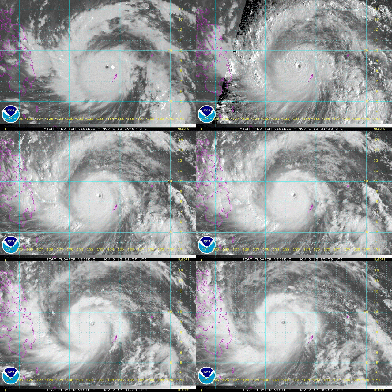
Satellite images of the typhoon posted by the US National Oceanic and Atmospheric Administration (NOAA) as of 10 am Thursday showed Yolanda having a small, defined eye, and the outer rain bands already approaching parts of eastern Mindanao and Visayas.
NASA said the typhoon's eye is small, around 8 nautical miles or approximately 14.8 km in diameter.
Weather Philippines, a Rappler partner, said in its update Wednesday morning that Yolanda has become an "extremely catastrophic super typhoon," and is now "the most powerful of all Super Typhoons for 2013."
The site said it is "similar in track but more powerful in strength of Super Typhoon Mike (PAGASA codename Ruping), which passed across the Visayas on November 12, 1990 and devastated much of Central Visayas, particularly Cebu."
It will start to weaken after it makes landfall, but will still be a strong typhoon as it exits the Visayas area.
"Residents living along the eastern seaboards of the Philippines from Northern Quezon, Bicol Region, down to Northeastern Mindanao should continue monitoring the approach of this destructive typhoon for possible unprecedented track changes," the update said.
'Equivalent to Category 5 storm'
 This animated image shows the MTSAT image of Typhoon Yolanda (Haiyan) between 19:57 and 02:57 UTC Nov 6-7 2013. Image courtesy NOAA
The US military's Joint Typhoon Warning Center (JTWC) has been referring to Haiyan/Yolanda as a "super typhoon," and as of its bulletin issued 2100 UTC (5 am Philippine time) the agency measured winds of 150 knots, or 278 km/h, near the center.
The JTWC also said the typhoon will still intensify, as sea surface temperatures "remain very favorable."
The Japan Meteorological Agency (JMA) puts Haiyan/Yolanda's intensity as "violent," and forecasts the system's barometric pressure to go to as low as 895 hPa within the day.
Haiyan is an "extremely dangerous Category 5 Super Typhoon," and is the fourth storm with such strength this year, according to Jeff Masters, a meteorologist with Weather Underground.
http://www.wunderground.com/blog/JeffMasters/comment.html?entrynum=2571
http://www.wunderground.com/blog/JeffMasters/comment.html?entrynum=2571
The categorization is based on the Saffir-Simpson hurricane wind scale, "a 1 to 5 rating based on a hurricane or typhoon's sustained wind speed," according to the US National Weather Service. A Category 5 storm is designated for storms with sustained winds of more than 252 km/h, and means "catastrophic damage will occur."
"With warm waters that extend to great depth, low wind shear, and excellent upper-level outflow, Haiyan will likely stay at Category 4 or 5 strength until landfall occurs between 03 - 06 UTC Friday in the central Philippine islands of Samar or Leyte," Masters wrote in his blog Wednesday.
PAGASA does not officially refer to typhoons of such strength as super typhoons, but it occasionally raises public storm warning signal number 4 for systems with winds of more than 185 km/h. –Rappler.com


No comments:
Post a Comment